About Me

I am an early career GIS Developer based in Columbus, Ohio. By leveraging my geospatial analysis, application development, and scripting background, I provide powerful data insights via dynamic platforms. Ensure streamlined user experiences marked by real-time data interaction. Automate internal workflows. Mobilize field data collection. Utilizing flexible web frameworks and robust scripting solutions is vital to maximizing the potential of GIS.

Areas of Specialization

Environmental

  • 2+ years of experience with research, writing, and application development in environmental fields.
  • Career exposure to topics such as forestry, invasive species, environmental policy, and restoration ecology.

Communication

  • 4+ years of experience in customer service roles.
  • Collaboration with volunteer organizations such as Mountain Valley Watch.
  • Academic experience writing thesis driven research papers and technical writing coursework.

GIS

  • 3+ years experience creating Esri-based maps and applications that are implemented into an AGOL/Enterprise environment.
  • Ability to optimize geospatial creations using tools like custom widgets, Arcade, and ArcPy.

Skills

Front-End Development

  • HTML
  • CSS
  • JavaScript
  • TypeScript
  • Arcade

Back-End Development

  • SQL
  • PostgreSQL
  • Microsoft SQL Server
  • PostGIS
  • Python
  • JavaScript
  • Batch File
  • NodeJS
  • Image/PDF Processing

GIS

  • ArcGIS Pro
  • ArcGIS Ex. Builder
  • ArcGIS Dashboards
  • Survey 123 Connect
  • ArcGIS StoryMaps
  • ArcPy
  • Model Builder
  • 3 GIS

Projects

*Click on a Project to Learn More*

BMP Audit Dashboard

ArcGIS Dashboard for BMP Audit

Purpose

Core Processes

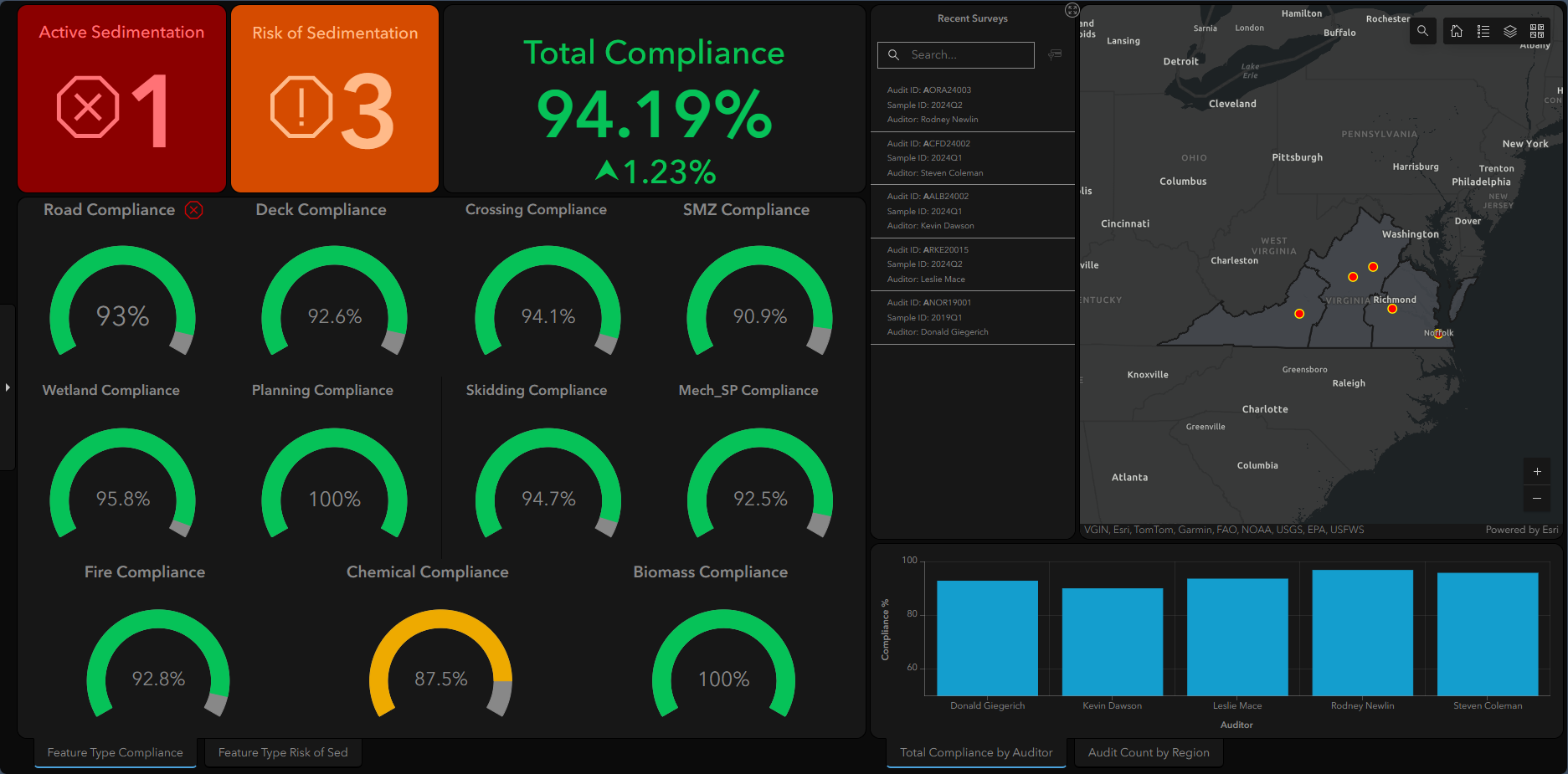
The objective of this dashboard is to display data from the BMP Audit Survey submissions while highlighting key business statistics.

  • Coded Arcade expressions to create dynamic display changes based on critial thresholds including color shifts, icon visibility, and a time-variable reference indicator.
  • Enabled content customization capabilites via a filtering element, an interactive ID list, and a dynamic map that alters content parameters by selecting boundary polygons and/or location points to express categorical data interests.
  • Created bar graphs personalized to individual user's workflows.

BMP Audit Survey

ArcGIS Survey for BMP Audit

Purpose

Core Processes

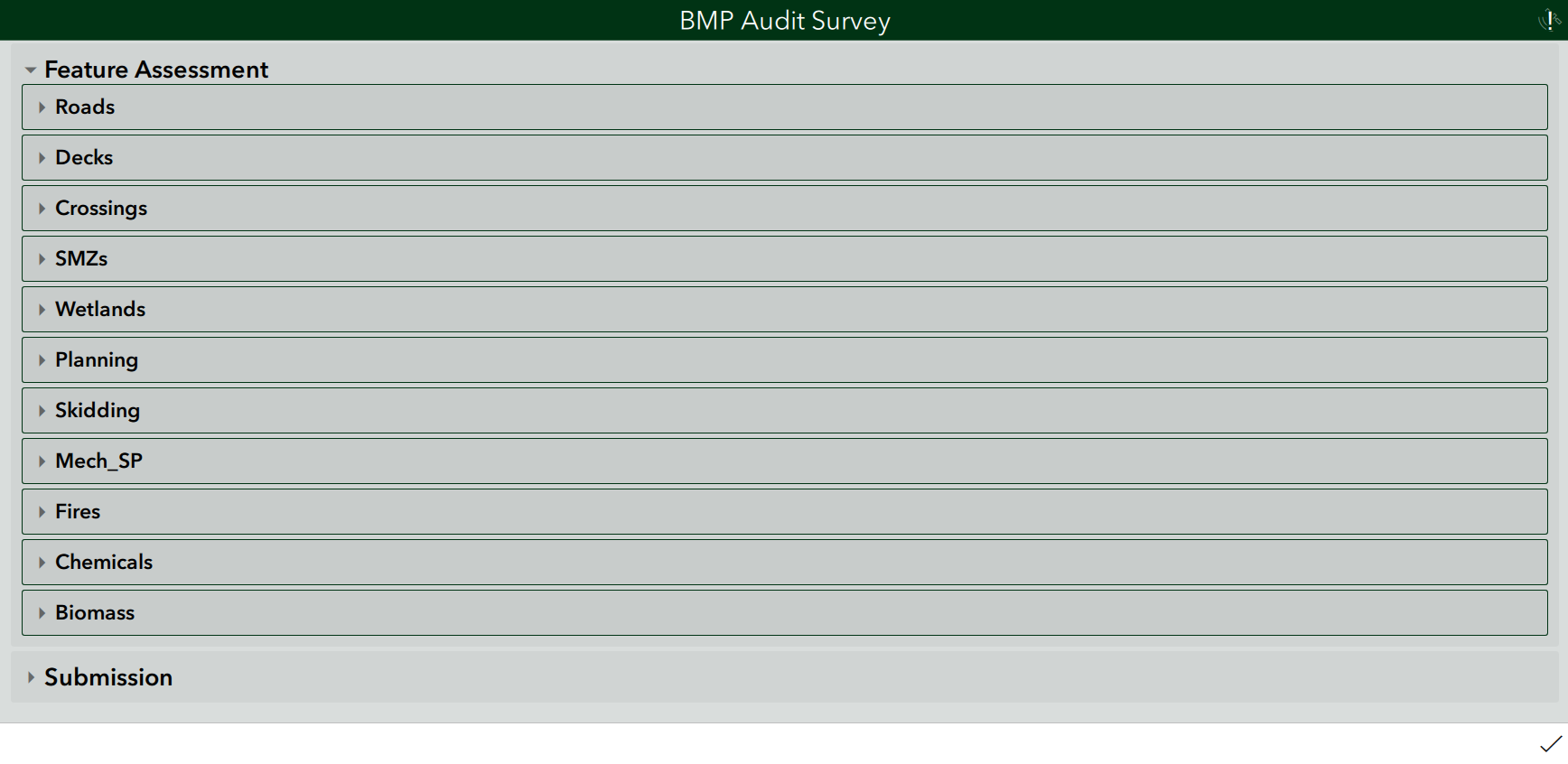
The objective of this survey is to provide Water Quality Specialists with the ability to collect BMP related data when in the field.

  • Implemented survey within module architecture to enable additional functionality like autocomplete of Audit ID details from related Harvest ID data and further statistical analyis by connecting its accompanying feature layer to other internal applications.
  • Customized question visibility and answer defaults to ensure data quality and aid userability.
  • Programmed nested boolean calculations to determine compliance percentages and risk/active sedimentation counts for external use in the BMP Audit Dashboard.

Spongy Moth Map

Spongy Moth Map

Purpose

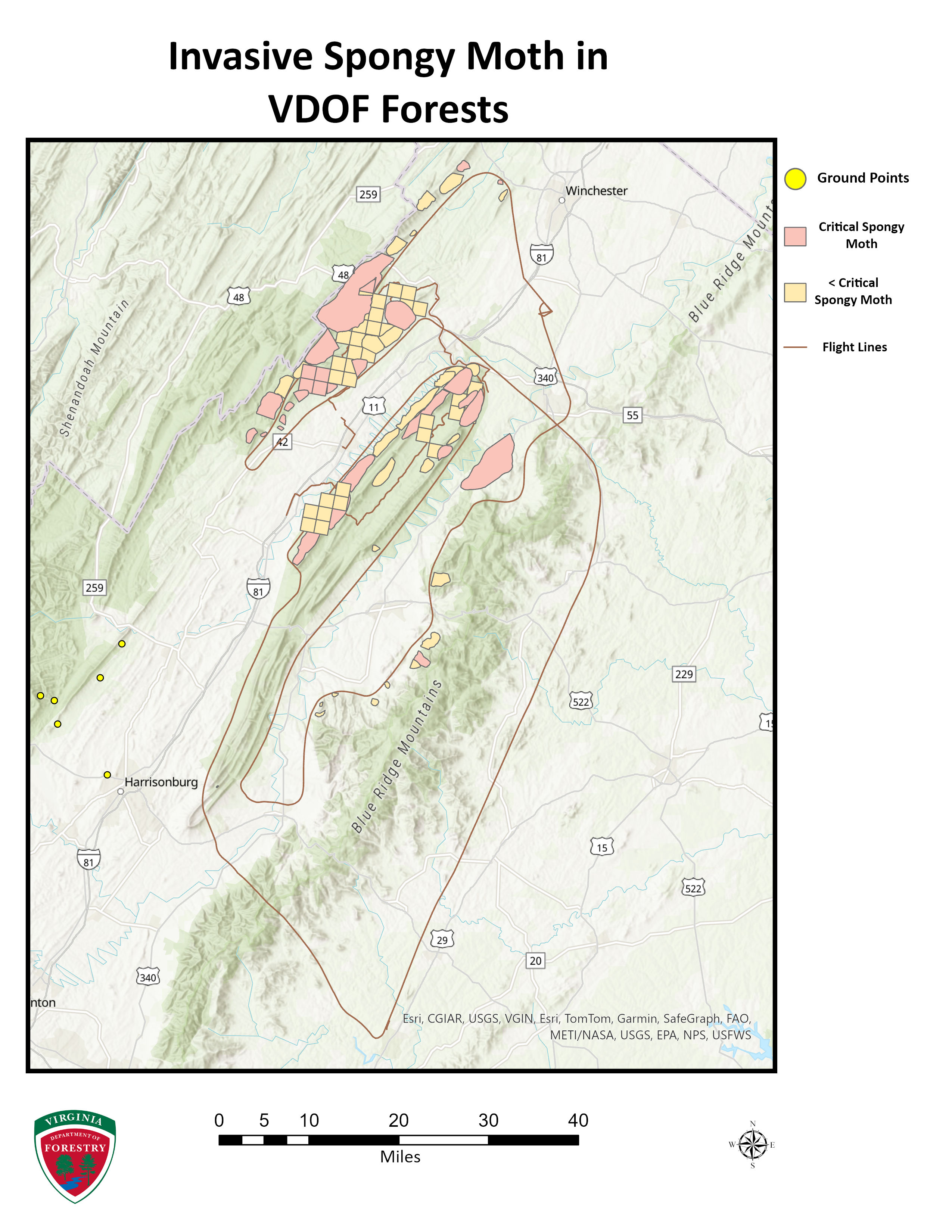
The objective of this map is to display tiered damage to trees in Northern Virginia from invasive Spongy Moths. The data for this project was collected from flightline imagery.

Core Processes

  • Utilized internal SQL statements to select for trees that are more vulnerable to damage from Spongy Moths.
  • Edited damage symbology to created ranked classes based on critical thresholds.

Voter Registration Map

Voter Registration Map

Purpose

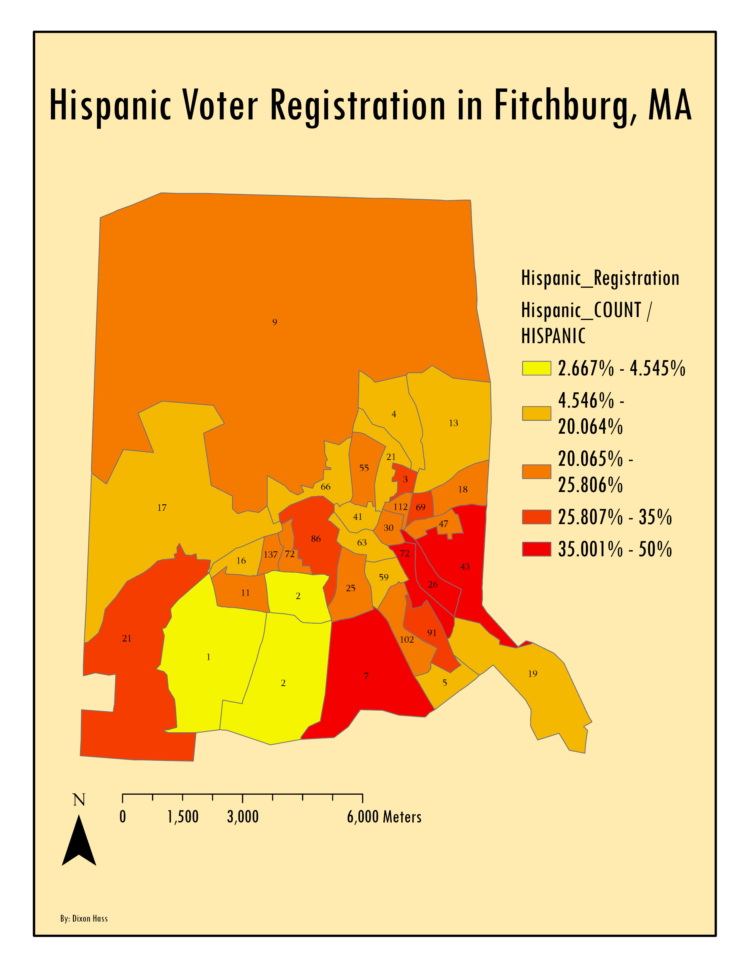
The objective of this map is to display Hispanic voter registration rate for each census block in the city of Fitchburg, Massachusetts.

Core Processes

  • Utilized Model Builder to efficiently find the number of voters for each ethnic group.
  • Conducted a spatial join to relate the X,Y point voter data to the Fitchburg census blocks.
  • Implemented a graduated color scale to highlight census blocks with the highest percentage of Hispanic Voters.

Reserve Sites Map

ArcGIS Reserve for BMP Audit

Purpose

Core Processes

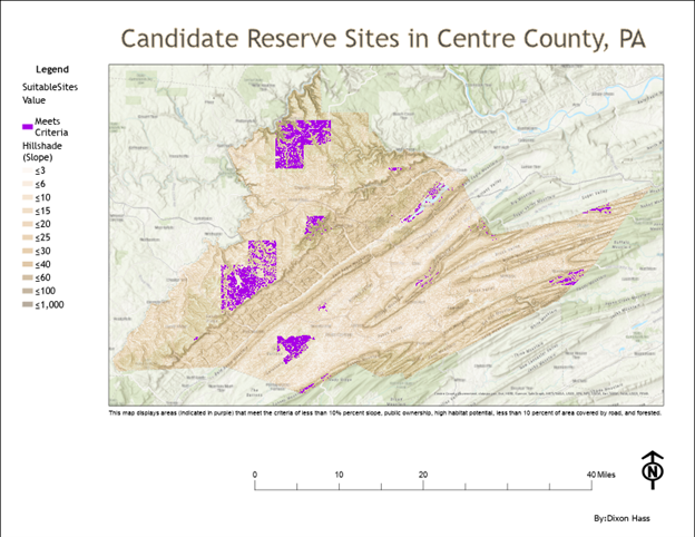
The goal of this map is to locate priority conservation areas in Centre County, Pennsylvania to effectively protect endangered species in the area.

  • Conducted a site selection analyis to find study areas that have high species richness and habitat quality by evaluating six seperate criteria and multiplying the resulting weighted raster layers.
  • Performed spatial joins and buffered roads to prepare individual layers for the suitability analysis.

Resume

Z